The world is going to war over maps
08 Sep 2026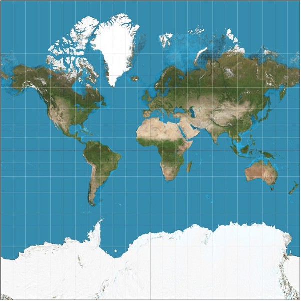
On September 4, the United States has effectively been told by the UN General Assembly that it has been looking a little too big for centuries. And Europe has been caught doing the same thing.
In a vote that could only happen at the United Nations, 164 countries backed a resolution encouraging governments, schools and technology companies to stop relying on maps that dramatically distort the relative size of continents.
There was one lonely vote against, the one from the United States.
The resolution takes aim at the world map most of us grew up staring at in classrooms, offices and airport departure lounges. Created in 1569 by Flemish cartographer Gerardus Mercator, the map was designed for sailors, not Instagram geography. It keeps compass directions accurate but dramatically enlarges landmasses as they move toward the poles. And is rather less excellent for anyone trying to understand geography.
That means Greenland can look almost as large as Africa, despite this continent being about 14 times bigger. Europe and North America also receive a generous cartographic boost.
Make Africa Great Again
Factually, Africa has not been undersized. The map has been oversizing everyone else. Togo led the African campaign, backed by the African Union, arguing that maps don’t simply show the world — they help shape how people understand it. The proposed remedy is Equal Earth and other equal-area projections, which represent the relative size of continents more accurately.
Naturally, this has become political. The Trump administration, famously fond of things being bigger, may not be thrilled. Washington dismissed the UN initiative as part of a “radical ideological project.”
US government’s officials are apparently preparing to fight the most dangerous geopolitical threat of 2026: a map that makes America look slightly less enormous.
Europe isn’t escaping either this resizing but looks more realistic. France has already said it plans to abandon Mercator for its world maps. The continent will therefore shrink before our eyes, at least on paper.
Nothing is actually shrinking. The US is still the US. Europe is still Europe. Africa hasn’t suddenly acquired extra square miles. It’s just that the map will stop giving northern countries a geographic Botox treatment.
The EU backed the resolution, while stressing that changing map projections has nothing to do with sovereignty or disputed borders.
Everyone wants their own map
There is actually an unavoidable catch: there is no perfect flat map of a round planet. Every projection sacrifices something — size, shape, distance or direction. The Mercator map is indeed not banished and will certainly continue to be used by many countries.
However, politics need to intervene in the debate. Africa is not the only place discovering that maps are rather useful political instruments. China has been for example drawing its own reality for years.
Beijing’s world maps put China in the middle of the world. It also incorporates territorial claims that extend well beyond what many other governments recognize, particularly in the South China Sea. China is continuing to reinforce those claims through mapping, surveys and what it calls its “one map” approach.
Russia has also its own cartographic tradition. Maps produced by Moscow depict Crimea and four Ukrainian regions — Donetsk, Luhansk, Zaporizhzhia and Kherson — as Russian territory, despite their status being rejected internationally. The Russian government already announced to produce a new official world map very soon…
Ukraine, meanwhile, recently objected to a UN map that visually separated Crimea from the rest of Ukraine, illustrating just how explosive a seemingly innocent piece of cartography can become.
Enters a potentially future Trump map, especially as the US president seems to demonstrate a peculiar interest in renaming geographical entities.
In a potential Trump-endorsed map, the Gulf of Mexico would obviously appear as the Gulf of America, Lake Ontario as Lake America. Google and Apple have already adopted the new name for US users, while Canadians continue to see Lake Ontario.
The latest cartographic blockbuster: New Mexico could become New America. New Mexico’s governor promptly made clear that the name was not up for negotiation. Canada could on a Trump map become “North America” and Greenland “Future American territory”. While Hawaii could even be designated “Pacific America,” for example.
At this rate, the next edition of the official US road atlas may need a warning: “Names may vary according to presidential mood.”
Let’s be however serious : the UN’s message ultimately tells only that maps should show us something about the world and its geography, in the fairest possible way.
And for travellers, there is a reassuring fact: flight times between destinations will not become shorter or longer, just because of a continent resized on a map!